C-119 Crash Outside Huntingdon, Tennessee
February 26, 1954
It
was a warm winter day in West Tennessee, with temperatures in the 50s
and moderate winds of about 8 MPH out of the south at McKellar Field,
an airport some forty miles to the southwest. Some people were working
outside; Mr. Homer Demoss, who lived a few blocks west of the Carroll
County
Courthouse, was working in his garden along with his colored hired
hand. T.W. Woods,
a US Naval Aviation veteran who had served as an aerial engineer on
Navy transports, was
working in a field just west of town about 200 yards to the left
(facing toward town) of the bridge on US 70 over Beaver Creek, a
tributary of West Tennessee's South Fork of the Obion River. Ernest
Smith, an Army Air Forces veteran who had become an aerial gunner on
B-17s and B-24s after washing out of pilot training, was about 1/2
block
from the northwest corner of the courthouse, along with Maurice Bunn,
standing on a ladder in the back of his truck. Royal Crider, a
bombardier in the Air Force Reserve in Memphis who had also washed out
of pilot training, was working in the post office just south of the
courthouse on Court Square. William West, an Air Force Reserve
navigator, was standing back of the funeral home about two blocks east
of the courthouse where Huntingdon Mayor Robert Murray was trying a
case. Huntingdon police chief George Hobbs was west of town on US 70
headed toward town. Other witnesses were at various points around
the vicinity of the courthouse. I myself was about twenty miles away at
Lavinia Elementary School in the southwest corner of the county no
doubt waiting impatiently for the bell to ring. I was a third grade
student and had just turned eight the previous November. As the son of
a World War II bomber crewmember and the nephew of an Air Force pilot,
I had a much stronger interest in aviation and airplanes, which to most
children my age were a curiosity. Other kids all
over the county and in Huntingdon were in their own schools gathering
up their things to
get ready to board the bus when the school bell rang in a few minutes.
It was Friday afternoon and everyone was looking forward to two days of
no school. No one had any inkling of the horrible tragedy that was
about to take
place in the winter skies over Huntingdon.
Earlier
that day US Air Force 1st Lieutenant Jack Jenkins and his crew, all of
whom were relatively new to the Air Force and to flying, took off from
their base at Lawson Air
Force Base adjacent to Ft. Benning, Georgia on what was supposed to be
a local training flight. Lt. Jenkins' orders were to spend an hour
practicing maximum performance landings there at Lawson then to
proceed to Brookley Air Force Base at Montgomery, Alabama to fly ten
practice ground controlled radar approaches (GCA). Upon their
completion he was to proceed to Columbus, Georgia airport and practice
Variable
Omni Range (VOR) approaches to finish up the six-hour training flight.
Lt. Jenkins never accomplished any of the assigned tasks - instead, he
took his crew in their nearly brand new C-119G - the airplane only had
110 hours on it - and proceeded northwest to his hometown of
Huntingdon, Tennessee to buzz the town. It turned out that he had done
the same thing two weeks before, on February 9. Although someone
complained to the Tennessee Highway Patrol, Federal aviation
authorities in Nashville later claimed they were not notified of the incident.
Lt.
Jenkins, who was known to his family and friends as Jackie, had grown
up around Huntingdon and graduated from
Huntingdon High School, probably in 1946 or 47 since he is reported to
have graduated from Bethel College, a Cumberland Presbyterian school in
nearby
McKenzie in 1951. While he was in
college. the Korean War broke out and Jack Jenkins joined the Air
Force immediately upon graduation. He applied for pilot training, which
he completed on June 21,
1952 and was rated as a US Air Force pilot and commissioned as an
officer. He was assigned to the
314th Troop Carrier Group at Ashiya, Japan where he spent the next year
flying as a copilot on C-119 Flying Boxcar transports on missions into
and over Korea. Upon completion of his overseas tour, he returned to
the United States and was assigned to the 777th Troop Carrier Squadron,
one of three squadrons of the 464th Troop Carrier Group at Lawson Field.
The 464th had been a bomber group during World War II flying B-24
Liberators from its base in Italy. The unit deactivated after the war
then reactivated at Lawson Field as a troop carrier wing in February,
1953. Lt. Jenkins joined the 777th in August. Although he was an
experienced pilot, he had less than the locally-required 1,000 hours for
assignment as an aircraft commander. Upon reaching that milestone, he
was upgraded and assigned as a first pilot, or aircraft commander, on
the C-119 in January 1954. However, Air Force records indicate
that he was an extra pilot in the squadron and had yet to be assigned
his own crew due to a shortage of qualified crewmembers.
On the day of the crash, Lt. Jenkins was flying with an inexperienced crew. His copilot only had a little over 400 hours, of which only about 50 was in the C-119. The flight engineer was equally inexperienced, with only a little over 50 logged hours. The second engineer was brand new to flying status. Lt. Jenkins himself had logged 1,188 hours, of which some 400 was in pilot training and most of the rest was on combat missions in Korea where the Flying Boxcars, as the C-119s were commonly called, were heavily involved in delivering cargo to remote airfields and dropping by parachute. His flight records show that he had just under 30 hours in B-26 bombers and another 19 or so in C-46 transports. All four of the crewmembers were in their early to mid twenties - Lt. Jenkins was 24. During the subsequent investigation, Lt. Jenkins was identified as an exceptional pilot with sound judgement - and had shown no indications that he would do what he did that tragic day. (He had made a similar flight two weeks before but his crew hadn't reported it to anyone. In those days there was no air traffic control system as there is today and no way of tracking an aircraft's flightpath. He was flying with a different set of crewmembers on the fateful day.) The events of that day can only be explained by youthful exuberance and the desire to make an impression on the folks back home. He did, but not in the manner he had expected.
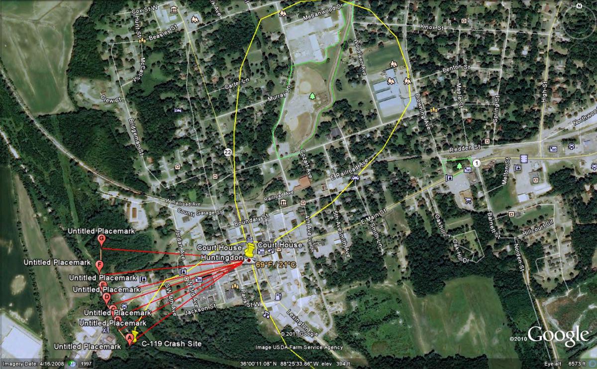
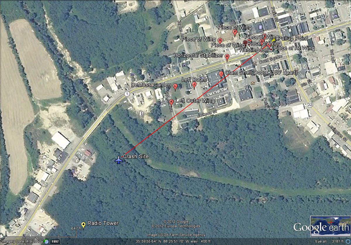
The
above diagram depicts the sequence of events as reported in the
statements of the witnessess - the yellow line depicts the airplane's
approximate path, although it may have actually been a bit more to the
south. The red lines and points sequenced A to G represent an arc 1,750
feet from the court house, the approximate distance the airplane
covered after it
started coming apart until it impacted the ground. (The distance is
approximate because the exact point at which the airplane began coming
apart is unknown. It was apparently believed to have been just east of
the courthouse since he was seen to initiate a steep pullup as he
approached the building.) Lt. Jenkins
approached Court Square from
the south and passed over it at an altitude estimated to be 100-200'.
(One witness puts his path a block or two to the east, but its not
supported by other witnesses.) After passing over the courthouse, he
began a "tight" right hand 270-degree turn which brought him back
toward the courthouse on a generally
westerly heading. While making the turn, he evidently
deliberately
passed over or close to Huntingdon High School. One witness
reported that he was traveling from northeast to southwest as he came
over Court Square. A couple
said the airplane came over the Bank of Huntingdon. It is
difficult to pinpoint exactly where the
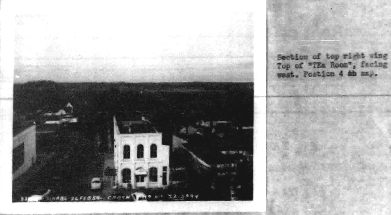
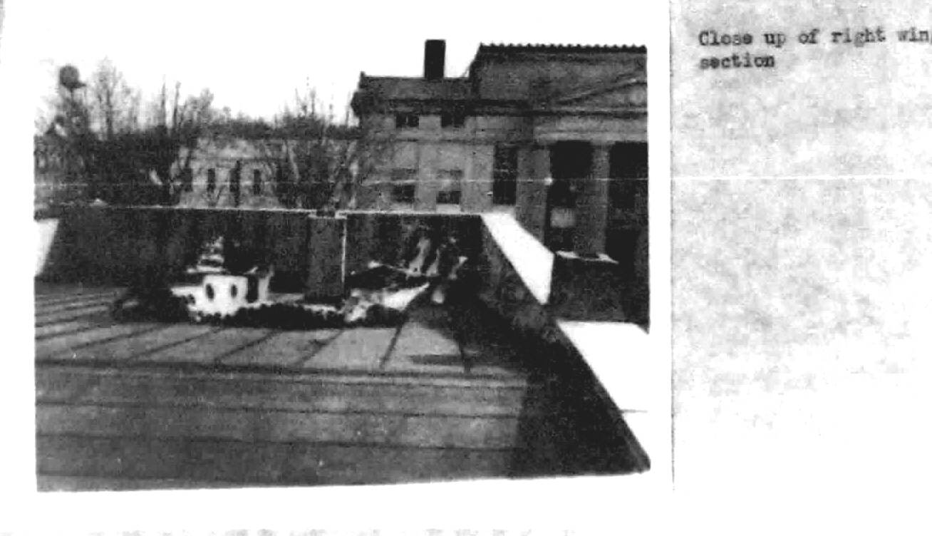
fuselage came over the courthouse although the location of a piece of
the outboard right wing on top of the building indicates the path was
somewhat to the south of the building. (C-119 wings were in two
sections, with the inner portion being from the fuselage to the boom
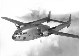
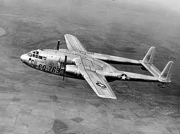
and the outer section outboard of the boom. See above photos.) The wing
span of a C-119 is 109
feet
and the courthouse is 110 feet long (southeast to northwest) and since
an aileron, which is at the end of the wing, landed on the courthouse
roof, the fuselage would have been south of the building. Each
witness saw
the events from a different angle. One, Royal Crider the post office
worker, said the
fuselage was over the street between the post office and the
courthouse. This would be commiserate with the location of the aileron
on top of the building. As he approached the courthouse -
the airplane
evidently
came over the bank on the opposite side of the street which would
indicate he was headed to the southwest - he began a
steep climbing turn to the right but, as soon as he did so, both wings
failed. A tearing of metal sound was heard by witnesses, followed by a
"whoosing" sound as high octane aviation gasoline, probably 115/145,
streamed out of the right wing and caught
fire, probably from contact with the engine exhaust. The airplane left
a trail of burning fuel along its flight path. Thr remaining fuel
exploded and caught fire right after the airplane impacted the ground
in a cornfield just outside the town. It is believed
that Lt. Jenkins applied full power as he started the pullup (he was
probably already at full power since he was estimated to be traveling
at
250 MPH) and that
the engines continued to run at full power all the way to the impact
point west of town. Photographs of the engine controls show the
throttles and propeller controls pushed all the way forward. The
accident investigation team determined that the
wings failed because Jenkins attemped to initiate a steep pullup
at a speed well in excess of the airplane's design limit manuevering
speed. The C-119C maneuvering speed is 187 MPH; Jenkins is believed to
have exceeded that speed by as much as 60 MPH. In short, he literally
pulled the wings off the airplane when he tried to make a sudden steep
climb. Some witnesses believed he was so low that he pulled up to avoid
hitting the building. After the wings failed, pieces of
the airplane kept
falling off along a path 1,200' long and 600' wide - the final accident
report says the stream of debris was 1,700' long. The right wing failed
in three places and the first pieces were found on top of the
courthouse. Other pieces were found on the courthouse lawn and in the
street. One piece fell on the roof of The Tea Room, a restaurant on the
corner of Main and Court Square. Some pieces were just north of
Main Street/US 70. All of those
pieces were from the airplane's right wing, which indicates the actual
path was further to the south, especially since there was a "strong"
crosswind from the south. (The actual wind velocity is unknown - the 8
MPH from the southeast given in the accident report is from Jackson,
the nearest weather reporting station. Winds may have been stronger at
Huntingdon based on the reports of several witnesses that there was a
"strong crosswind.") The
horizontal stabilizer fell into the street 400 feet west of the
courthouse lawn and landed on top of
two trucks. The left boom fell off and came to rest 700 feet from the
courthouse. The outer section of the left wing, which failed and folded
backward along the left boom, was found 1,000
feet to the west. My recollection that there was an automobile
dealership in this vicinity at the time, possibly Priest Motors. Part
of the wreckage landed on the roof. (Some
local people, including school children who passed through on busses
later in the day,
believed they saw blood scattered all over this area. Since the
fuselage and cockpit was still intact at this point, there would have
been no blood; the crewmembers died on impact 750' further to the
southwest. They most
likely saw hydraulic fluid which streamed out when the left wing and
boom seperated. The Air Force used Mil 5606 hydraulic fliud, which is
bright red in color. There was a general state of hysteria and
confusion in Huntingdon after the crash, and except for a few men with
military aviation experience, few people realized what they were
seeing.)
Ernest Smith stated that when the boom came off,
the airplane "shunted,"
meaning it changed direction, and the boom "slipped off to the left."
This is consistent with a turn toward the left which took the remains
of the airplane to the point of impact. Burning gasoline fell on the
garden
where Mr. Homer DeMoss was working. He was burned so badly they had to
be hospitalized as was a young colored man working with him. The
flaming gasoline fell on a team of mules and wagon, setting the wagon
on fire and burning the mules. They had to be destroyed. Both wings,
the horizontal stabilizer
and the
left boom had come off of the airplane but even though the engines were
on fire, the fuselage and cockpit
remained intact along with the right boom until the airplane impacted
in a field 1,750' from where it began coming apart. The entire sequence
of events
occured in just a few seconds, probably no more than five. The USAF
investigators believed the
failing airplane inscribed a parabolic, an arc, meaning that it was
gaining altitude for about the first 1/2 of the flight, then started
losing it as it made its fiery
journey to where it came to earth. (It did not fall straight to earth
when the wings came off because of momentum. The inner wings were still
producing some lift but not enough to keep the remaining components
airborne. After the wings came off, the remnants became a projectile.)
However, T.W. Wood, who
was closest
to the impact point, reported that it maintained about the same
altitude until it was about 100 yards from where it finally struck the
ground. The airplane was diving at about a 60-degree angle at the time
of impact and both engines were running at full power, although the
right one was on fire. Accident investigators determined the power
turbines (turbochargers) were intact.
The above image depicts the most likely location of the
impact point based on the 1,750 foot measurement given in the accident
report. Due to Beaver Creek's northwest/southeast orientation, the
measurement does not allow for an impact point further north. For
instance, immediately north of the US 70/Main Street bridge 1,750 feet
would be right in the middle of the creek. Measurements of the initial
impact point from the creek bank place it at 110', with the debris field
extending to the left on an angle for approximately 300' to the southwest. Considering
the effect of momentum, the debris field extended along the aircraft's
line of flight at the time it impacted the ground.
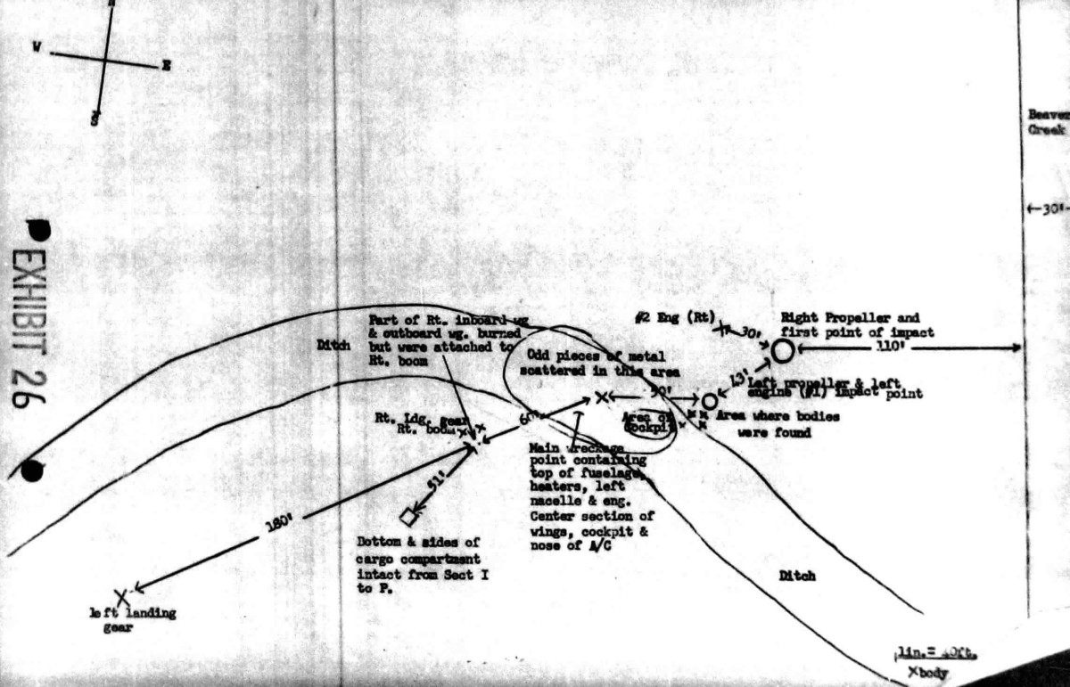
The above diagram shows the impact point at 110 feet from Beaver Creek, which runs in a northwesterly direction just to the west of Huntingdon. The bank of the creek is depicted on the right, with the impact point 110' from it in a straight line. After impact, the wreckage continued in a southwesterly direction. Three bodies were found at a point 43' from the point of initial impact and the fourth was in the ditch. The main wreckage rolled into a drainage ditch - the accident report relates that it was "nearly demolished." This ditch was deep enough that the cockpit and top of the fuselage are not visible in the photograph of the debris field. Parts of the airplane, including the bottom and sides of the cargo compartment, came to rest about 100 feet from the drainage ditch and 51 feet from where the right boom and part of the right wing came to rest. The left landing gear came to rest 240 feet from the center of the ditch. The total spread of the wreckage from the impact point is approximately 300-342 feet. (The
total shown in the diagram is 342 feet, but there is an angle involved.)
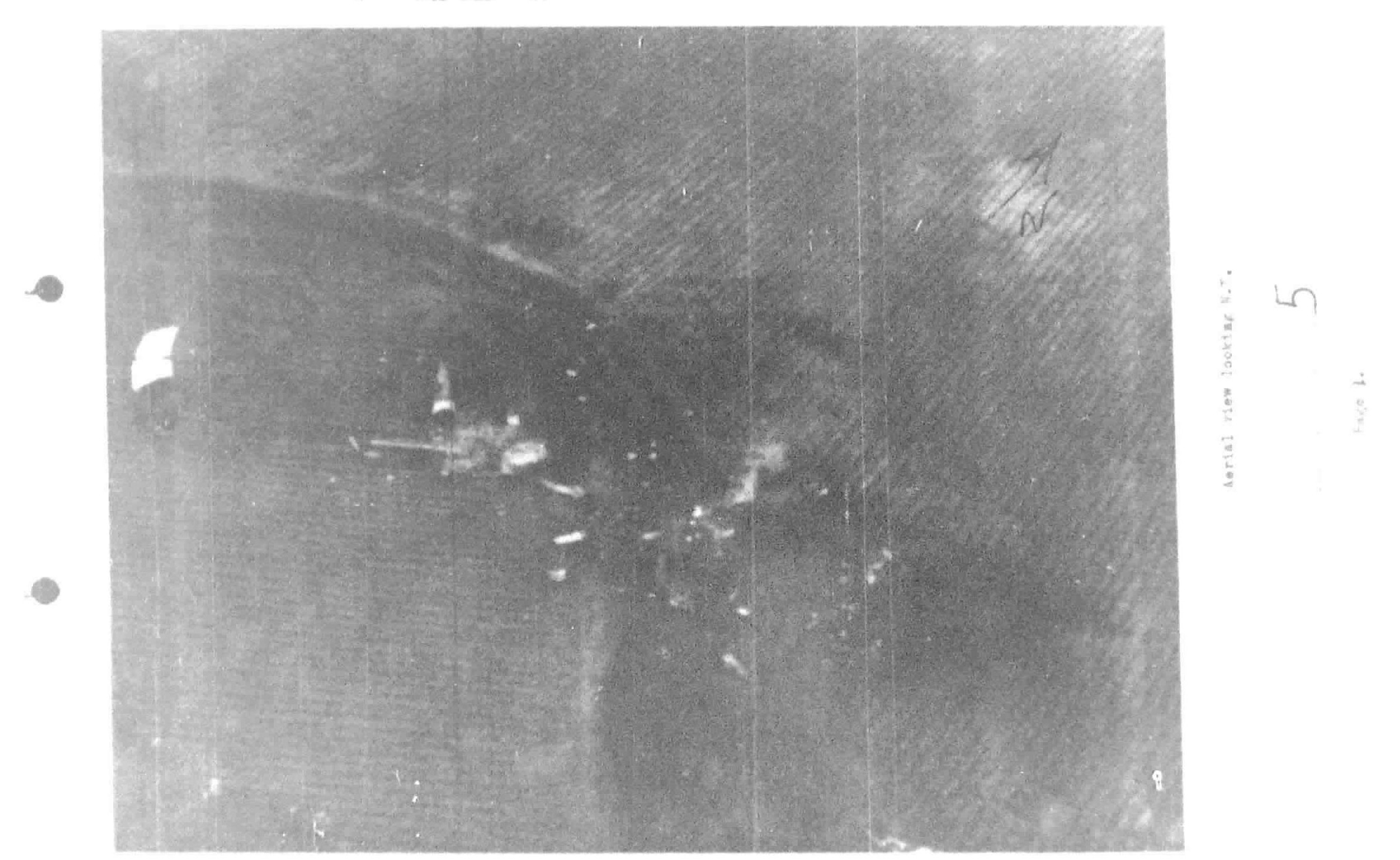
The above aerial photo shows the
wreckage along the drainage ditch. The lines in the
photograph are probably the remnants of corn rows from the previous
year's crop. Note that the debris field is spread along a
northeast/southwest line. This is an indication that the remains of the
airplane were headed southwest at the time of impact. The area of the
crash was allowed to grow up and is now covered by woods but the
outline of the ditch is visible in the Bing Maps image linked below.
(There appears to be a drainage ditch some 300 feet north of US 70 in recent satellite imagery but
it does not match the contour shown in the diagram and is some 2,000 feet from the courthouse. Furthermore, there
were several buildings along the northwest side of 70 at the time. No buildings are visible in the aerial photograph.)
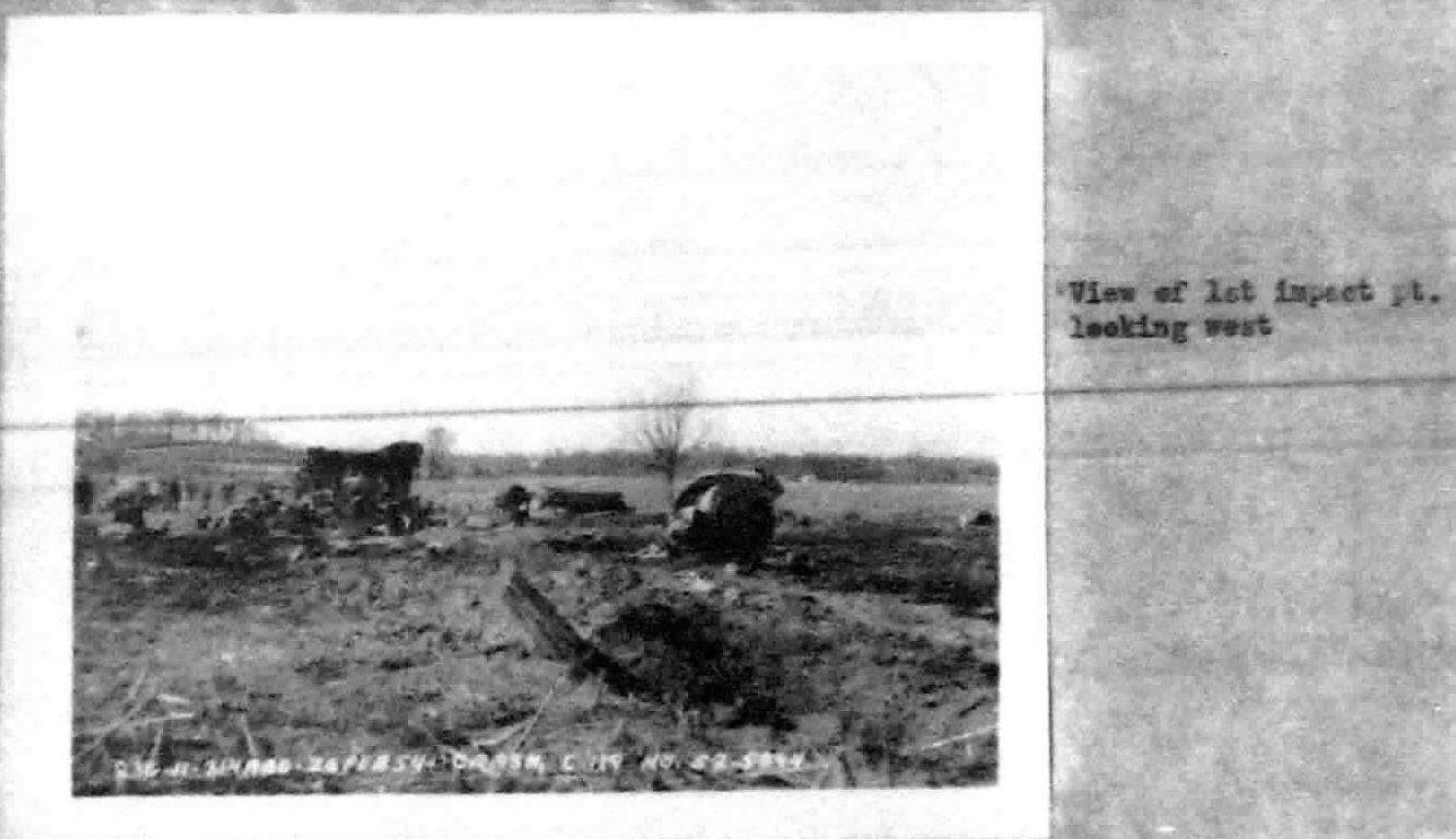
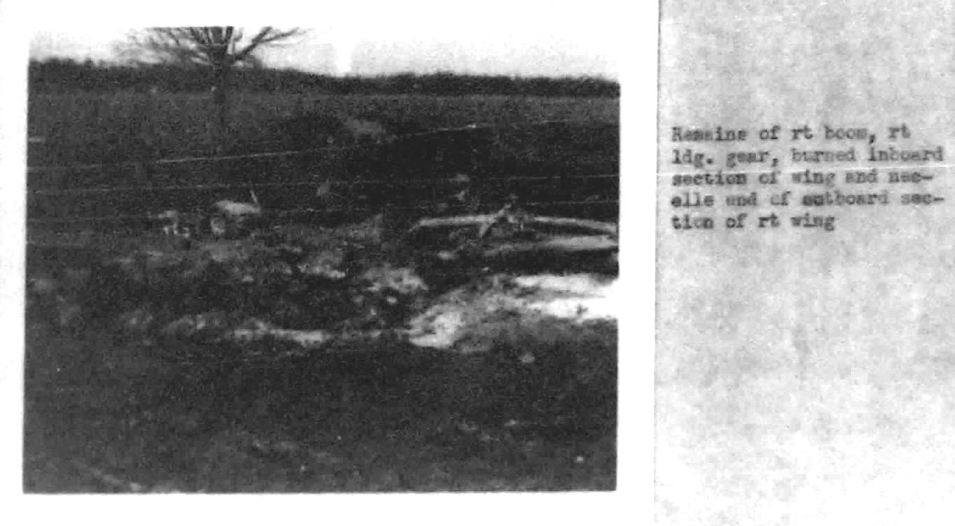
The
above photo is of the impact point looking in a westerly direction.
Note the higher terrain in the background at the edge of the bottom.
In 1954 Highway 77 around the west side of Huntingdon south of US 70
had yet to be built. The photographer was facing away from Beaver
Creek, which was right behind him, looking in a westerly direction. The object in the foreground is a
propeller blade - it dug into the ground. Immediately behind it is the
left engine nacelle. Note the small white building in the background to
the right of the nacelle. It's the service building for a radio tower
that was located in the field. It may not be there now. Due to the
distance from the camera and its small diameter, the tower itself isn't
visible.The larger
object to the left is part of the fuselage or cargo compartment. Note
the figures behind and to the left of it for perspective. The
photograph was no doubt taken with a wide angle lens. The debris field
is several hundred feet and the hills in the background are over a
quarter mile away.
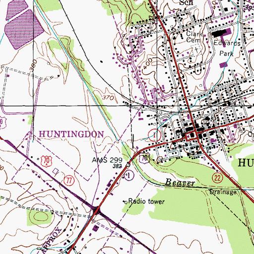
Above is the Huntingdon segment of the Palmer Shelter topographic map of the area. (The Palmer Shelter map has since been redrawn and is less detailed. This one was downloaded in 2011-2012 and was dated in the 1990s.) Note the location of the radio tower. There was a small white building - small square adjacent to the circle representing the antenna - at the base. The circular area to the northwest of the intersection is the hill visible in the preceding photograph. Here is a link to the current map.
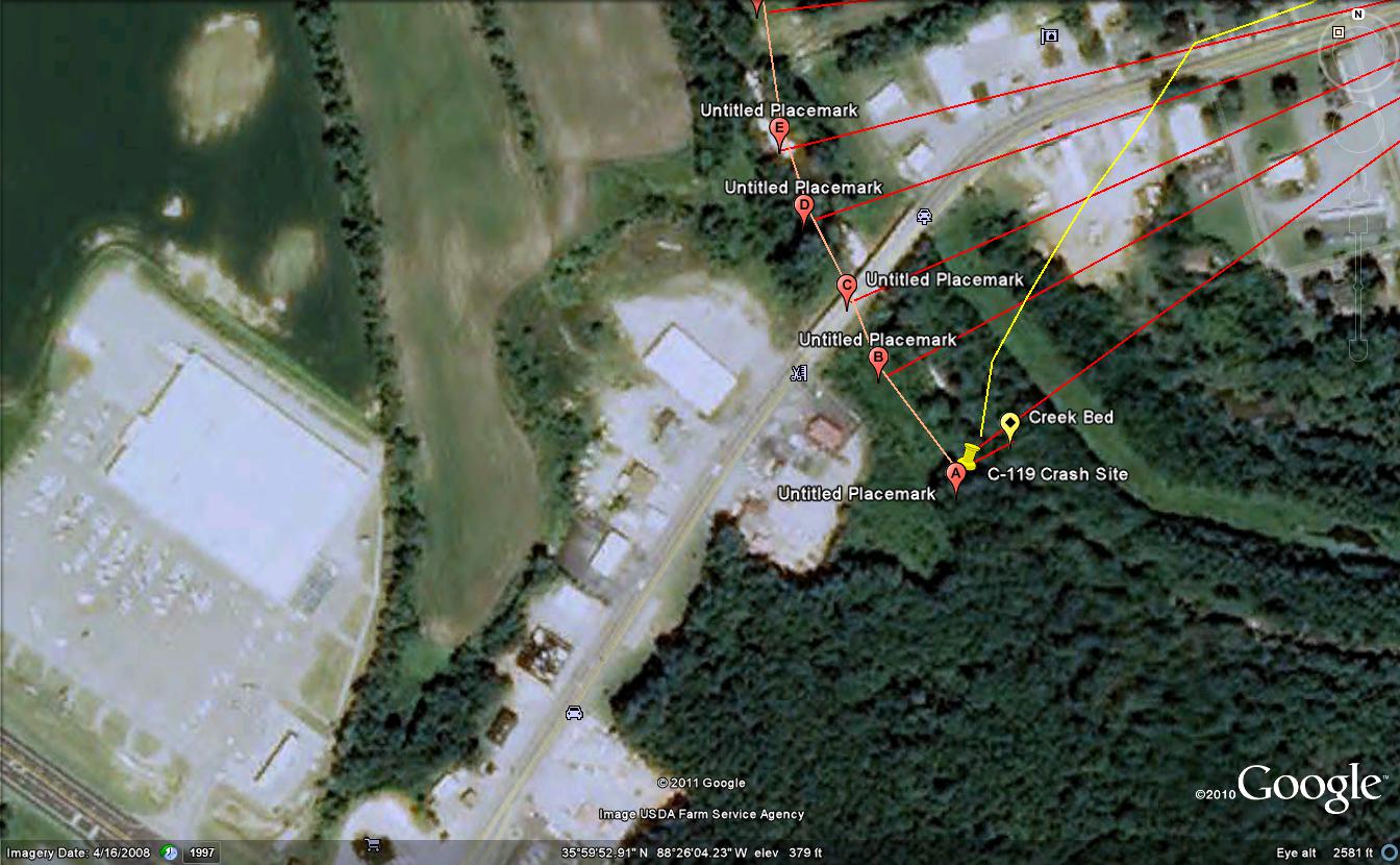
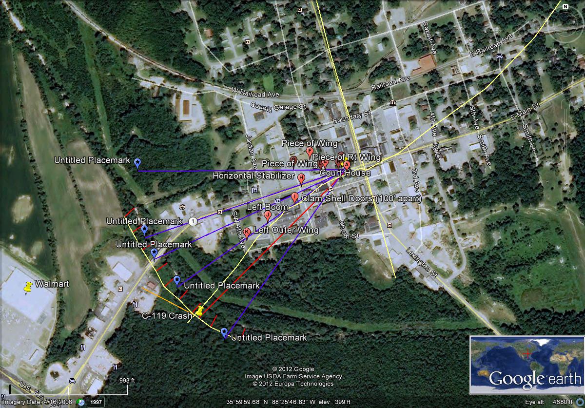
The
above photograph is of the area as it is today (April, 2008.) The large
building on the left is Walmart. Somewhere near Point A is the most logical place for
the impact point to have been - and is where I have always remembered
it as being. The
only place north of US 70 where it could possibly have
been would have been at Point D, but if the airplane impacted there,
some of the wreckage would have been in US 70 and the debris field
would have been strewn across it. T.W. Wood was working in
the field left of the bridge (North) at approximately 200 yards from it
(600') as reported in his statement. He saw the airplane from the time
it started coming apart over the courthouse until it crashed, but makes
no mention of the crash site being close to his immediate area. A plot
of the
position using a line 110' from Beaver Creek and 1,750 feet from the
courthouse places the impact point near the shown position. (Plotting
a position on a map is very simple - draw a line a specified
distance from a known reference line, in this case 110' from the
creek, then construct an arc using the known distance from another
known reference point, in this case 1,750' from the courthouse, and
where the two lines intersect is the point you're looking for - the impact point of the remainder of the C-119.) The plot
does not allow an impact point north of US 70 at all; the intersection
point is in the vicinity of Point A as shown on the map.
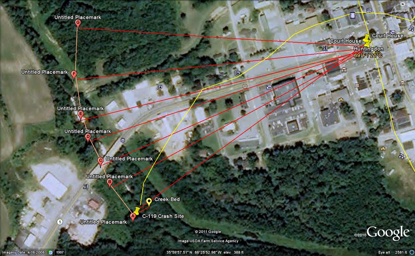
The above picture is of the plot of the crash site, using information from the accident report. The biege line represents a line running parallel to Beaver Creer. The blue vectors represent 1,750 feet from the courthouse, with the red line from the courthouse to the biege line intersecting with the parallel line. The crash site has to be at or near this point. The orange line is a direct line from US 70 to the crash point, a distance of just over 500 feet. This plot was made using a closer view of the crash site to make
the measurements from the creek
bed.
The
accident and the sight of the wreckage when I went up there the next
day with my family made an impression on me that has been with me for
all of my life. Every time I passed by the area on the way into
Huntingdon I thought about it. As it turns out, nine years later I
became a member of the 464th Troop Carrier Wing, the unit to which Lt.
Jenkins and his crew were assigned. I was not aware of this, however,
until I found some information on the Internet. I had always thought
the airplane was from Sewart AFB near Nashville. I also had thought
that the accident was caused by a stall, but it turns out it was
actually caused by structural failure. He was reportedly going around
250 MPH when he came over the courthouse on his last pass, far in
excess of the maximum manuevering speed (Va) at which a pilot can
safely
execute an abrupt maneuver. I did not understand what had actually
happened until I obtained a copy of the accident report.One of my
friends is a retired Air Force officer who was on the board. He told me
they foundt that the wings had failed before I decided to order a copy
of the report. The accident was a real
tragedy, and as it is with accidents, it didn't have
to happen.
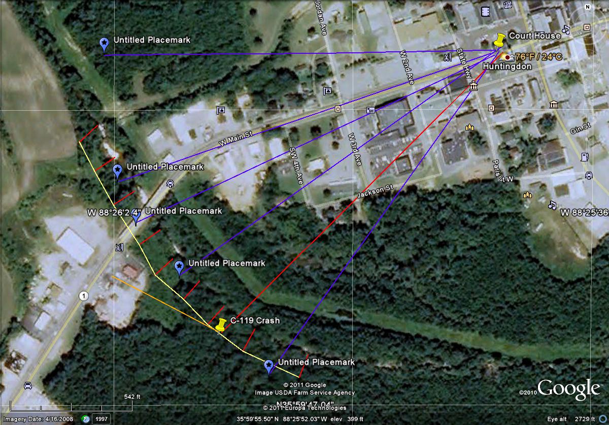
After considering the information regarding pieces of debris and where
they were found in relation to the courthouse, I realized it is
possible to determine the airplanes approximate path based on where
they were found and plotted them as shown above. Specific locations are
given for the pieces of wing found in the vicinity of the courthouse,
on top of the Colonial Tea Room and in the Electric Company parking lot
as well as the horizontal stabilizer, which landed on the street.
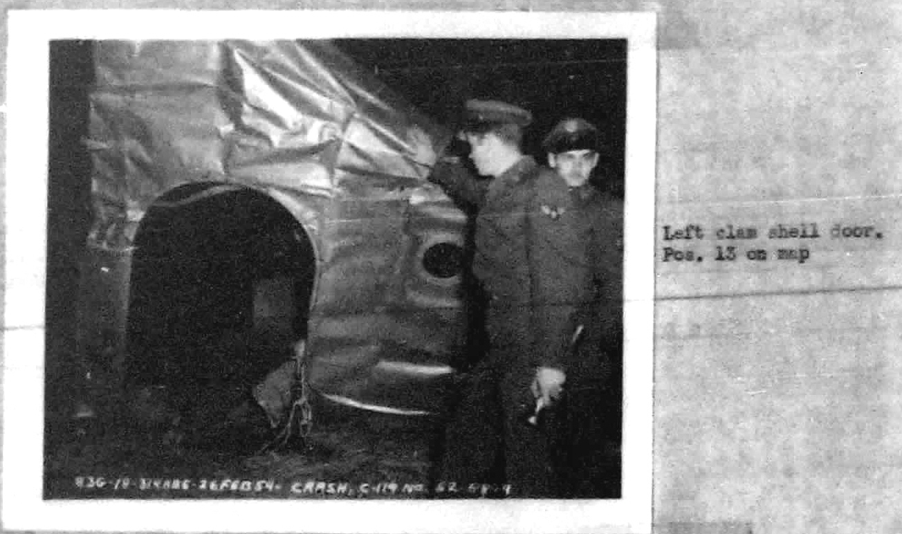
Distances are given for the clam shell doors, which fell 100' past the
horizontal stabilizer 100' apart, the left boom and the left outer wing
- which actually folded back along the boom when the airplane started
coming apart over the courthouse but didn't come disconnected from the
rest of the wing for at least another 1,000 feet. When considering
where the pieces fell, it is important to remember two things - that
all of the pieces around the courthouse, the Colonial Tea Room and
Carroll County Electric were from the right wing and that there was a
strong wind from the south which would have caused them to drift
north
of the actual flight path. A;though the actual wind at Huntingdon at
the time of the crash is unknown, winds at Jackson were out of the
south 8 MPH. However, witnesses reported that there was a "strong
crosswind" when Jenkins came over the courthouse. How far they drifted
would depend on how
high the airplane was when they came off - at least one witness
estimated it reached 255 feet altitude. Because the pieces were
aluminum
and, in the case of the horizontal stabilizer was an air foil, they
would not fall straight to earth but would come down in an erratic
manner like a falling leaf and drifting to the north as they
fell. The clam shell doors were large pieces made
primarily of aluminum and would have floated down in the same manner.
The pieces are
identified by red markers marked in sequence A to K. The debris field
was 600' wide and 1,700 feet long.
There seem to have been a lot of rumors that were spread after the
crash. One is that Jenkins had told people that he was going to "take
the flag off of the courthouse." The intial report was that the
airplane struck a flag pole, but it turned out to be in error. For that
matter, it is questionable that there was a flag pole on top of the
courthouse in 1954. It's not there now but is on the grounds on the
west side of the building. (Regarding directions, the courthouse
actually is constructed on a northwest-southeast line. There is also a
significant magnetic variation in West Tennessee, meaning that West on
a compass is actually about 267 degrees in relation to True North.) All
of the witnesses
interviewed by Air Force investigators agreed that the airplane didn't
strike anything before it started coming apart. Another rumor is that
Jenkins was actually standing in the back of the airplane when it came
over Huntingdon. Well, considering that the C-119G is equipped with
large clamshell doors at the back of the cargo compartment, how anyone
on the ground could see someone standing in the back is beyond my
comprehension, unless a paratroop door had been removed . Even if one
or the other of the paratroop doors was
open, it's unlikely that any of the crewmembers were in the rear since
they all had seats in the cockpit. It is possible that the crew in the
cockpit might have
been visible, especially when the airplane was in a bank. There is no
doubt that the clamshell doors were
installed because they were found on the ground in the debris field.
C-119s were flown without the clamshell doors on airdrop missions and
its possible they weren't installed on the first flight, but unlikely
since it was February, he was not on an airdrop mission and he flew
over 300 miles to reach
Huntingdon. Then there is the question of why Jenkins would have left
the cockpit to go to the back of the airplane and leave an
inexperienced copilot to fly the airplane while performing a classic
buzz job! People who knew him have said that Jenkins was a
"daredevil" which may very well be true but Air Force investigators
reported that he hadn't exhibited any reckless behavior. In fact, one
of his supervisors said that Jenkins was the last man in the squadron
he'd have suspected of buzzing. One witness,
who had served as an intelligence officer in an Army Air Forces combat
unit in World War II, and knew him well, described him as a quiet and
well-mannered young
man. Some have also
said that he
was taken out of fighters and put into transports but his record
doesn't indicate this. His record indicates that he completed Air Force
pilot training and was commissioned in June, 1952 and went almost
immediately to Japan to
his first assignment with the 314th Troop Carrier Group. He returned to
the United States a year later and was assigned to the 777th Troop
Carrier Squadron in August 1953. It is very
possible that his recklessness had been suppressed prior to his upgrade
to first pilot because he had always flown as a copilot and was under
another pilot's supervision. Another rumor is that he was engaged to a
girl who was still going to high school, which I find a bit hard to
swallow since he was 24 years old and had been out of high school for
almost seven years. One witness mentioned that he was engaged to one
of the girls' at the high school's older sister, which is more likely.
Some believed he flew
over the school to impress a girl, but while he no doubt intended to
fly over or close to the school, it would have been hard for an
airplane that size to make a circle to the east and not pass over it.
He was supposed to have flown over the school at that particular
time because he knew the girl would be outside in some kind of sports
or cheerleading practice - but the accident occured in February. The
temperature that day was in the 50s. In fact, his arrival over
Huntingdon at that particular time is more likely due to his time of
takeoff from Lawson Field. A newspaper account was published right
after the crash that stated
that the airplane hit a house after passing over the courthouse. This
report turned out to be false, however. It also stated that it sheared
off a flag pole, but this report was also untrue according to the
witnesses interviewed by USAF flight safety investigators the following
day. There is another question - a number of men claimed they went to
the site and helped pull the bodies out of the airplane but the police
chief witnessed the crash from a quarter mile away and was one of the
first people there. He states that he took immediate action to secure
the area and keep people away from the site until Air Force personnel
could arrive to begin their investigation. (The accident report
indicates that the bodies were thrown out of the airplane when the
cockpit was demolished during the impact and subsequent tumbling. The
police chief said he and his fellow law enforcement officers covered
them with parachutes and left them until military authorities in the
form of local National Guard personnel, arrived to take possession of
them. With Air Force approval, the bodies were removed and taken to a
local funeral home.)
It's important to understand how aircraft accident investigations are
conducted. First, all wreckage must be secured by law enforcement to
prevent people from looting and to insure that the wreckage remains
where it fell until investigators can make note of the position.
Precise measurements are taken using surveying equipment and placed
onto a diagram and/or map. In this case, the accident report refers to
a map of the debris and positions of the witnesses but it was not
included in the packet I received
from the people who obtained the report from the Air Force and offered
it for sale. Statements are taken from witnesses to the accident,
including from crew and passengers if there are survivors. In the case
of the Huntingdon crash, a number of statements were taken, with the
majority from men with military aviation experience. All were
from men who actually saw the airplane start coming apart over the
courthouse and/or saw the final impact. Also, it is important to
understand that the sole purpose
of the investigation is to determine what happened and why in order to
prevent future occurences. In this case, the intent of the accident
investigation was
to determine what caused it, which turned out to be structural failure
due to the pilot exceeding published airspeed limitations. All
available pieces of wreckage were
retrieved by Air Force personnel from Sewart AFB, Tennessee at Smyrna,
and taken there and reassembled so they could be studied by experts
including aeronautical engineers. Military accident reports are
classified as "Special Handling Required" and are not released to the
general public. Once the investigation has been completed, the report
is disseminated to the various military organizations "with a need to
know." However, in the 1960s the Department of Defense allowed
the public release of accident reports through 1955. Accident reports
since then may be obtained by filing a Freedom of Information request.
They are copied on to microfilm and stored at the Office
When I first read the accident report and since, I wondered why Jenkins would have initiated a turn to the right when he would have been in the left seat of the airplane - he was the aircraft commander or first pilot whose seat is always the left seat. After re-reading the report numerous times, I realize that he may not have. According to witnesses and the location of the pieces of the right wing, the first part of the airplane to fail, he started a pullup and the airplane started coming apart just as he came over the courthouse. That a piece of the wing fell on the courthouse roof is an indication that he started the pullup and the airplane started coming apart before he was over it. Bear in mind that the pieces were traveling at the same speed as the airplane when they came off of it and fell in a parabolic, with drift caused by the crosswind. There is no doubt that the airplane banked to the right as it climbed but this may have been due to the sudden decrease in lift as the right wing failed. Some witnesses indicated that he was on a westerly heading but one said his heading was more southwesterly, which is consistent with the airplane having passed over the bank then over the south end of the courthouse. Since there was a south wind - winds at Jackson were reported at 8 MPH out of the southeast - the falling pieces would have drifted to the north of the airplane's actual path. That one part fell on the Tea Room is an indication that the flight path was south of Main Street since the Tea Room is on the north corner of Main and Courtsquare. The pieces that fell the furtherest north fell on the electric company but they were parts of the wing and would have been more affected by the wind than a more solid object would have been because it would have taken them longer to fall (they would have been falling like a leaf, not a rock.) Royal Crider, who worked in the post office, stated that he was standing behind the building and witnessed the airplane from the time it appeared over the street south of the courthouse until it went into the field west of town. The accident report states that the airplane went west on a heading of 270 degrees but a heading and the actual relationship to True North are not the same. Compass headings are based on magnetic north while True North is based on the North Pole and there was considerable magnetic variation in West Tennessee in 1954 as this map shows. This is important because maps are based on True North. The line of zero declination has shifted several hundred miles to the west since 1954. Today's declination for McKellar Field is 1 degree west but in 1954 it was at least 3 degrees west. In fact, the sliding scale indicates that in 1954 the declination in West Tennessee may have been as much as five degrees. This would mean that magnetic north, the reading from a compass, could have actually been 265 degrees True. (To determine True North, the magnetic variation is either added or subtracted from the magnetic heading, in this case 270 degrees with westerly variation added. There is a common saying "East is least and West is best," meaning easterly variation is subtracted and westerly is added to the magnetic heading.) Since the variation was around 5 degrees in 1954, the True couse would have been 5 degrees less than the compass heading. Ernest Smith also reported that the airplane "shunted" when the left wing and boom came off, which indicates a change
of Air Force
Safety.
While I have a vivid memory of seeing the wreckage, I don't recall exactly how or when my family learned of the crash. My dad was an Army Air Forces aerial engineer in World War II and we were a very air-minded family so it was natural that we'd be interested. This was in the days before our family had a television and we often had the radio on and tuned to a local station in either Huntingdon or McKenzie. I believe we had recently had a telephone installed and someone - probably my Uncle Larry McGowan - may have called and told us about it. There was an article in the Memphis Commerical Appeal, to which we subscribed and recieved by mail, the next morning. (The article was erroneous in that it claimed Jenkins had hit a house.) I know that I went to Huntingdon the following day, most likely with Uncle Larry. My recollection is that he came by and picked up Daddy and me and possibly my sister to go to Huntingdon to see the crash site. (I to this day wonder why Daddy wanted to see the crash site. He had seen a number of crashes when he was in England during the war. Perhaps he wanted me to see it so I'd think twice about learning to fly. Even though I was only 8 1/2, I had already developed a very strong interest in aviation and was planning to learn to fly when I grew up - I did, my entire adult life prior to retirement was spent around airplanes.) My view was from US 70 looking at the wreckage from the north, as confirmed by the diagram in the accident report since I saw the section of main landing gear, which went the furtherest from the point of impact in a southeasterly direction. What I most recall is seeing the field of wreckage, with a wheel and tire lying flat and thinking about how a large airplane could be reduced to pieces. That image has remained forever in my mind. I also seem to recall an open parachute amongst the debris. The police chief said in his statement that they covered the bodies with parachutes. I don't recall seeing the demolished cockpit, which was lying in the drainage ditch. I also know that every time after that whenever our family had occasion to go to or through Huntingdon I would look over at the field and see it littered with the wreckage. I would also notice the Demoss House. Some how, I got the impression the pilot was Demoss' son and didn't learn otherwise for many years. There is one thing for certain - seeing the many pieces of
in direction. He indicates the shunt was to the airplane's left,
or to the south or southwest.
what had once been a large, powerful airplane made an
impression on me that I have carried ever since.
Return to Home Page
Links and Sources:
C-119 Page - Nothing specific to the Huntingdon crash, but a good source to learn more about the airplanes and their mission.
Bing Birdseye Map
of area as it is today.
Published September 23, 2011
Updated July 2, 2012
Last update September 19, 2017